
Portal:Western Australia
Introduction
 Western Australia (commonly abbreviated as WA) is a state of Australia occupying the western third of the land area of Australia, excluding external territories. It is bounded by the Indian Ocean to the north and west, the Southern Ocean to the south, the Northern Territory to the north-east, and South Australia to the south-east. Western Australia is Australia's largest state, with a total land area of 2,527,013 square kilometres (975,685 sq mi). It is the second-largest country subdivision in the world, surpassed only by Russia's Sakha Republic. the state has 2.76 million inhabitants—11 percent of the national total. The vast majority (92 percent) live in the south-west corner; 79 percent of the population lives in the Perth area, leaving the remainder of the state sparsely populated. The first Europeans to visit Western Australia belonged to the Dutch Dirk Hartog expedition, who visited the Western Australian coast in 1616. The first permanent European colony in what is today Western Australia occurred following the landing by Major Edmund Lockyer on 26 December 1826 of an expedition on behalf of the New South Wales colonial government.[text–source integrity?] Lockyer established a convict-supported military garrison at King George III Sound, at present-day Albany, and on 21 January 1827 he formally took possession for the British Crown of the western part of the continent that was not already claimed by the Crown. This was followed by the establishment of the Swan River Colony in 1829, including the site of the present-day capital, Perth. (Full article...)
|


-8a.jpg)


(Northern
Territory) |
 Good articles -
-


Abyss is a steel roller coaster located at the Adventure World amusement park in Perth, Western Australia. The $12-million attraction was announced in April 2013, and construction began the following month. It opened to the general public six months later on 1 November 2013.
The Abyss is a Euro-Fighter, a roller coaster model from Gerstlauer that features a "beyond-vertical" first drop which exceeds 90 degrees. In addition to several inversions, the Abyss reaches a top speed of 85 kilometres per hour (53 mph) along the two-minute, 630-metre-long (2,070 ft) ride. (Full article...) -
Butler railway station is a suburban railway station in Butler, a suburb of Perth, Western Australia. It is the terminus of the Joondalup line, which is on the Transperth rail network. Planning for the Joondalup line in the Butler area began in the late 1990s. The station was built as part of a A$240 million extension of the Joondalup line from Clarkson to Butler. Construction began on the station on 16 July 2012, and was completed on 16 May 2014, opening on 21 September 2014. On 15 July 2024, an extension of the Joondalup line from Butler to Yanchep will open.
Butler station has two side platforms situated in a cutting below the surrounding ground level. It is accessed from a ground-level concourse. Services run every 10 minutes during peak and every 15 minutes between peak. The journey to Perth Underground station is 40.7 kilometres (25.3 mi) and takes 38 minutes. The station is served by six regular bus routes, operated by Swan Transit under contract. To the south, these bus routes link to Clarkson station, traversing through several suburbs along the way. To the north, these bus routes go as far as Two Rocks, on the northern edge of the Perth metropolitan region. (Full article...) -

The sandbar as viewed from Point Walter.
Point Walter (Noongar: Dyoondalup) is a point on the Swan River, Western Australia, notable for its large sandbar that extends into the river. It is located on the southern shore of Melville Water, and forms its western end. Point Walter is located in the suburb of Bicton, approximately 12 kilometres (7 mi) south of the Perth central business district, and 7 kilometres (4 mi) north-east of Fremantle, and is on the opposite side of the river to the suburbs of Mosman Park, Peppermint Grove, and Dalkeith.
Point Walter is a site of Aboriginal Australian heritage, both for its place in the Dreamtime and because of the local Whadjuk people's historical activities at the site. Named in 1827 by James Stirling, it was popular among the public for its variety of recreational activities and its facilities, such as tea rooms, a bathing house and a tavern. Through a series of events, the point suffered a drop in patronage from the late 19th century to World War II. At that time, it was rehabilitated from a state of disrepair, and an army camp was built on the premises, which was later transformed into a migrant settlement camp. Since the migrant camp's closure in 1972, the facilities have been used for multiple activities. (Full article...) -
Clarkson railway station is a commuter rail station in Clarkson, a suburb of Perth, Western Australia. It is on the Joondalup line, which is part of the Transperth network. Located in the median of the Mitchell Freeway, the station consists of an island platform connected to the west by a pedestrian footbridge. A six stand bus interchange and two carparks are located near the entrance.
Planning for an extension of the Joondalup line north of Currambine railway station was underway by 1995. The government committed to an extension to Clarkson the following year, and a plan detailing the extension was released in 2000. The first contract for the project, a A$14 million earthworks contract, was awarded to Brierty Contractors in March 2001. In April 2002, Barclay Mowlem and Alstom were awarded a contract worth $17 million to design and build the extension's rail infrastructure, and in November 2002, a $8.7 million contract was awarded to Transfield for the construction of the station. The station opened on 4 October 2004, with five new Transperth B-series trains entering service that day. The following day, bus services in the area were realigned to feed into Clarkson station. On 3 September 2013, there was a minor train crash at Clarkson station. On 21 September 2014, an extension of the Joondalup line 7.5 kilometres (4.7 mi) north to Butler railway station was opened. (Full article...) -
Sherwood railway station (officially Sherwood Station and previously known as Kingsley Station) is a suburban railway station in Armadale, a suburb of Perth, Western Australia. It is on the Armadale line which is part of the Transperth network, and is 28.6 kilometres (17.8 mi) southwest of Perth station and 1.8 kilometres (1.1 mi) north of Armadale station. The station opened in 1973 as Kingsley, but was renamed to Sherwood in 1993. It consists of two side platforms with a pedestrian level crossing. It is not fully accessible due to steep ramps, wide gaps at the pedestrian level crossing, and wide gaps between the platform and train. Services are operated by Transperth Train Operations, a division of the state government's Public Transport Authority. Peak services reach seven trains per hour in each direction, whilst off-peak services are four trains per hour. (Full article...) -
Redcliffe railway station is a station for underground commuter rail services in Redcliffe, east of Perth, Western Australia. The station is one of three stations that were built as part of the Forrestfield–Airport Link project and is served by Transperth's Airport line services.
The contract for the Forrestfield–Airport Link, which consists of 8 kilometres (4.97 mi) of twin bored tunnels and three new stations, was awarded to Salini Impregilo and NRW Pty Ltd in April 2016. Forward works, which included the permanent closure of Brearley Avenue between Great Eastern Highway and Dunreath Drive, began in 2016. Construction began in mid-2017, and by June 2018, excavation was complete. The two tunnel boring machines (TBMs) reached the station in mid-2019, having tunnelled from High Wycombe, and left tunnelling towards Bayswater after several weeks of maintenance. Construction of the station infrastructure followed. (Full article...) -
Great Northern Highway is an Australian highway that links Western Australia's capital city Perth with its northernmost port, Wyndham. With a length of almost 3,200 kilometres (2,000 mi), it is the longest highway in Australia, with the majority included as part of the Perth Darwin National Highway. The highway, which travels through remote areas of the state, is constructed as a sealed, predominantly two-lane single carriageway, but with some single-lane bridges in the Kimberley. Economically, it provides vital access through the Wheatbelt and Mid West to the resource-rich regions of the Pilbara and Kimberley. In these areas, the key industries of mining, agriculture and pastoral stations, and tourism are all dependent on the highway.
In Perth, the highway begins in Midland near Great Eastern Highway, and further north intersects the Reid and Roe highways, which together form Perth's ring road. There are also three rural highways that spur off Great Northern Highway. Brand Highway and North West Coastal Highway provide an alternative coastal route between Muchea and Port Hedland, while Victoria Highway carries the National Highway route and interstate traffic into the Northern Territory. Various road routes are allocated to sections of Great Northern Highway, including the Highway 1 routes National Route 1 and National Highway 1, as well as National Highway 95. (Full article...) -
The First Commonwealth Paraplegic Games were held in Perth, Western Australia, from 10 to 17 November 1962. These Games preceded the 1962 British Empire and Commonwealth Games which were held in Perth from 22 November to 1 December of that year. The Commonwealth Paraplegic Games were conceived by George Bedbrook after Perth won the right to host the Commonwealth Games. Great support was received from Royal Perth Hospital, a leading spinal rehabilitation centre in Australia.
These games raised the profile of paraplegic (spinal cord and polio) athletes in Australia, particularly Western Australia. The chairman of the Organising Committee, Hugh Leslie, who had lost a leg in World War II, gave a speech aimed to change public perceptions about disabilities by addressing the power of language. These games, he told the audience, "were designed to prove to the public that the person who was bodily handicapped was not a cripple, and he hoped that that horrible word would eventually be wiped out of use. He had a slogan which he hoped would be adopted by all disabled: 'I can, I will'". (Full article...) -
Eyre Highway is a 1,664-kilometre (1,034 mi) highway linking Western Australia and South Australia via the Nullarbor Plain. Signed as National Highways 1 and A1, it forms part of Highway 1 and the Australian National Highway network linking Perth and Adelaide. It was named after explorer Edward John Eyre, who was the first European to cross the Nullarbor by land, in 1840–1841. Eyre Highway runs from Norseman in Western Australia, past Eucla, to the state border. Continuing to the South Australian town of Ceduna, it crosses the top of the Eyre Peninsula before reaching Port Augusta.
The construction of the East–West Telegraph line in the 1870s, along Eyre's route, resulted in a hazardous trail that could be followed for interstate travel. A national highway was called for, with the federal government seeing the route's importance in 1941, when a war in the Pacific seemed imminent. The highway was constructed between July 1941 and June 1942, and was trafficable by January 1942. It was originally named Forrest Highway, after John Forrest, by the war cabinet. It was officially named Eyre Highway, a name agreed upon by the states' nomenclature committees. (Full article...) -
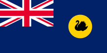
The flag of Western Australia consists of a Blue Ensign defaced with the badge of the state. Adopted in 1953 to replace a similar design used from the time when the state was still a British colony, it has been the flag of Western Australia since 3 November of that year. The design of the present flag entailed reversing the direction of the black swan so that it faced towards the hoist. This was done in order to adhere to vexillological convention. Western Australia's flag is similar to the flags of the other five Australian states, which are also Blue Ensigns with their respective state badges. When flown with those state flags and the national flag, it is sixth in the order of precedence. This is indicative of its position on the Commonwealth Coat of Arms. (Full article...) -
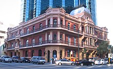
The Palace Hotel in Perth, Western Australia, is a landmark three-storey heritage listed building located in the city's central business district. Originally built in 1897 as a hotel during the gold rush period of Western Australia's history, it was converted to banking chambers and offices in the 1980s and now accommodates the Perth headquarters of Woods Bagot, Adapptor and Hatchd. The building is located on the most prominent intersection in the financial district of the city, at the corner of St Georges Terrace and William Street.
When the hotel opened for business on 18 March 1897 it was, although slightly smaller than some of its contemporary buildings in other capital cities in Australasia, described as "... one of the most beautiful and elegant hotels in Australasia". Other praise included: "... redolent of the bourgeois luxury and splendour of the Paris of Napoleon III" and later "... in its day, as sumptuous a hostelry as any in Melbourne or Sydney." It operated as licensed premises from 1897 until 1981. (Full article...) -
Severe Tropical Cyclone Bobby set numerous monthly rainfall records in parts of the Goldfields-Esperance regions of Western Australia, dropping up to 400 mm (16 in) of rain in February 1995. The fourth named storm of the 1994–95 Australian region cyclone season, Bobby developed as a tropical low embedded within a monsoon trough situated north of the Northern Territory coastline on 19 February. The storm gradually drifted southwestward and later southward under low wind shear, strengthening enough to be assigned the name Bobby by the Australian Bureau of Meteorology (BoM). The storm rapidly deepened as it approached the coast of Western Australia, and attained its peak intensity of 925 mbar (hPa; 27.32 inHg) at 0900 UTC on 24 February with 10-minute maximum sustained winds of 195 km/h (120 mph). After making landfall as a somewhat weaker cyclone near Onslow, the remnants of Bobby drifted southeastward, gradually weakening, before dissipating over the southern reaches of Western Australia.
Bobby inflicted minor damage throughout Western Australia, dropping copious rainfall and forcing the closure of many facilities and roads. The storm's destruction was most severe in Onslow, where 20 residences suffered damage. Elsewhere, Bobby knocked out power and water supplies, unroofed houses, tore off rain gutters, toppled fences, and smashed windows. The flooding of a 17 km (11 mi) stretch of the Eyre Highway stranded approximately 1000 vehicles, although the backup was later cleared more than a week later. Flooding disrupted mining and drilling operations throughout southwestern Australia, costing the industry upwards of $50 million (1995 AUD; $38.7 million USD). Numerous Australian Army and State Emergency Service (SES) personnel were involved in cleanup and recovery efforts after the cyclone's passage, while power and water service was restored to those cut off during the storm. Overall, the cyclone caused eight deaths and $11 million (1995 AUD; $8.5 million USD) in damage along its course across Western Australia. (Full article...) -
Eucalyptus rhodantha, commonly known as rose mallee or rose gum, is a species of straggly mallee or shrub native to parts of Western Australia. It has smooth bark and a crown composed entirely of circular to heart-shaped juvenile leaves arranged in opposite pairs and attached directly to the stems with no stalks. The flower buds appear singly in the leaf axils and are red, the fruits hemispherical to conical and pendent. The rose mallee is grown as an ornamental shrub suitable for gardens in hot and dry climates. It is found more often in urban gardens and cultivation than in the wild and is readily available in seed form.
E. rhodantha was first formally described in 1938 by the Australian botanists and collectors William Blakely and Henry Steedman from material collected by Steedman near Gunyidi, Western Australia in 1934. , Plants of the World Online listed the formerly accepted Eucalyptus rhodantha var. petiolaris as a taxonomic synonym of E. rhodantha. (Full article...) -
The GST distribution dispute is an ongoing political controversy concerning the distribution of goods and services tax (GST) revenue amongst the Australian states and territories and the federal government. The dispute was originally based upon Western Australia's (WA) dissatisfaction with its low returns, which led to reform in 2018. The 2018 reform guarantees all states and territories a minimum return on their contribution.
As a result of WA's improved financial position during and after the COVID-19 pandemic, debate has since centred around the suitability of the minimum payments floor introduced. Currently, the federal government provides a "no worse-off guarantee", meaning that states and territories receive either the funding they would have under the old system or the new system, whichever is higher. This prevents the reform causing disadvantage to any jurisdiction during the transition period, which will expire in 2029–30. Several states have held inquiries and have alternatively demanded the federal government undo the reform or continue contributing to the GST pool. Criticism has also been levelled at the expenses the federal government incurs subsidising states under the no worse-off guarantee. (Full article...) -
Linda Yunkata Syddick Napaltjarri (born c. 1937) is a Pintupi- and Pitjantjatjara- speaking Indigenous artist from Australia's Western Desert region. Her father was killed when she was young; her mother later married Shorty Lungkarta Tjungarrayi, an artist whose work was a significant influence on Linda Syddick's painting.
Linda Syddick was one of many Western Desert women who took up painting in the early 1990s, as part of a broader contemporary Indigenous Australian art movement. She began painting some time prior to 1991, when her work was first exhibited in Alice Springs. Her work includes a distinctive fusion of Christian and Aboriginal traditional themes and motifs. She has been a finalist in the National Aboriginal & Torres Strait Islander Art Awards on at least four occasions, and in the Blake Prize (a religious art competition) at least three times. Her works are held by numerous galleries including the National Gallery of Australia, the Art Gallery of New South Wales and the Art Gallery of South Australia. Linda Syddick was the subject of a portrait painted by Robert Hannaford, which was a 1992 finalist in Australia's premiere portrait competition, the Archibald Prize. (Full article...)
_1.jpg)


.jpg)


Did you know (auto-generated)

- ... that Mertome Village in Bayswater, Western Australia was the first aged care complex to be built by a local government in Australia?
- ... that Western Australia was the second Australian state to legalise voluntary assisted dying?
- ... that Bill Dunn, an Indigenous Australian pastoralist approaching retirement, sold his station at half-price to the Jigalong community despite receiving full-price offers from non-Indigenous people?
- ... that Nick Goiran, a member of the Western Australian Legislative Council, proposed 357 amendments to a voluntary assisted dying bill?
- ... that the search for a lost radioactive capsule along a 1,400-kilometre (870 mi) stretch of road in Western Australia was likened to looking for a needle in a haystack?
- ... that politician John D'Orazio helped to secure a three-year trial of daylight saving time in Western Australia?
Categories

More portals
More did you know...

- ...that when the 1987 America's Cup was raced off Fremantle, Western Australia it was the first time for 132 years that the regatta had not been hosted by the New York Yacht Club?
- ...that the original Victoria Dam, constructed in 1891, was the first dam in Western Australia, and it stood for almost 100 years before being replaced with the current dam?
- ...that Anglican bishop Kay Goldsworthy was consecrated as the first woman bishop of any Australian church on 22 May 2008?
Related WikiProjects

Things you can do
Here are some tasks you can do to help with WikiProject Western Australia:
Associated Wikimedia
The following Wikimedia Foundation sister projects provide more on this subject:
-
 Commons
Free media repository -
 Wikibooks
Free textbooks and manuals -
 Wikidata
Free knowledge base -
 Wikinews
Free-content news -
 Wikiquote
Collection of quotations -
 Wikisource
Free-content library -
 Wikispecies
Directory of species -
 Wikiversity
Free learning tools -
 Wikivoyage
Free travel guide -
 Wiktionary
Dictionary and thesaurus


