
User:Gazamp/Safekeeping
| {{{1}}} |
|2=
|2=

The Andes (/ˈændiːz/ AN-deez), Andes Mountains or Andean Mountain Range (Spanish: Cordillera de los Andes; Quechua: Anti) are the longest continental mountain range in the world, forming a continuous highland along the western edge of South America. The range is 8,900 km (5,530 mi) long and 200 to 700 km (124 to 435 mi) wide (widest between 18°S and 20°S latitude) and has an average height of about 4,000 m (13,123 ft). The Andes extend from South to North through seven South American countries.: Argentina, Chile, Bolivia, Peru, Ecuador, Colombia and western Venezuela.
Along their length, the Andes are split into several ranges, separated by intermediate depressions. The Andes are the location of several high plateaus—some of which host major cities such as Quito, Bogotá, Cali, Arequipa, Medellín, Bucaramanga, Sucre, Mérida, El Alto and La Paz. The Altiplano Plateau is the world's second-highest after the Tibetan Plateau. These ranges are in turn grouped into three major divisions based on climate: the Tropical Andes, the Dry Andes, and the Wet Andes. (Full article...)
Selected general articles
-

Volcán Marmolejo is a 6,108 m (20,039 ft) high Pleistocene stratovolcano in the Andes on the border between Argentina and Chile. It is located 9 km (6 mi) NNE of the active San José volcano, and is the southernmost 6,000 m (19,685 ft)-plus peak in the world. The Argentine portion is within the Argentinean protection area of Provincial Reserve for Multiple Use and Natural Recreation Manzano / Portillo de Piuquenes. It is on the border of two provinces: Argentinean province of Mendoza and Chilean province of Cordillera. Its slopes are within the administrative boundaries of the two cities: Argentinean city of Tunuyán and the Chilean commune of San José de Maipo. (Full article...) -
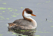
The Titicaca grebe (Rollandia microptera), also known as the Titicaca flightless grebe or short-winged grebe, is a grebe found on the altiplano of Peru and Bolivia. As its name implies, its main population occurs on Lake Titicaca. Lake Uru Uru and Poopó, the Rio Desaguadero, and small lakes that connect to Lake Titicaca in wet years, serve as "spillovers" territory. In the past, the population was larger and several of these lakes – such as Lakes Umayo and Arapa – apparently had and may still have permanent large colonies (BirdLife International 2006). It is sometimes placed in Podiceps or a monotypic genus Centropelma. Its local name is zampullín del Titicaca. (Full article...) -
Azufral is a stratovolcano located in the department of Nariño in southern Colombia, 12 km (7 mi) west of the town of Túquerres. It is the only volcano of the Western Ranges of the Colombian Andes. Its name derives from the Spanish word for sulfur, azufre. The volcano is considered semi-dormant but there are numerous fumaroles in the summit crater. The summit of the volcano has an altitude of 4,070 metres (13,350 ft), and the north-western side of the crater contains a crescent-shaped lake named Laguna Verde (English: Green Lake) at 3,970 m (13,025 ft). The lake is 1,100 m (0.68 mi) long and 600 metres (2,000 ft) wide. and its bright green color is a result of the sulfur and iron-based deposits in the crater. There are also two other much smaller lakes in the crater, Laguna Negra (English: Black Lake) and Laguna Cristal (English: Crystal Lake).
The volcano lies within a nature reserve, the Reserva Natural del Azufral, created in 1990. The reserve covers an area of 5,800 hectares (58 km2) and is free of charge to enter. As Azufral is semi-dormant, there are no restrictions on ascending the volcano and visiting Laguna Verde: there is a road that climbs to within 1.5 kilometers (1 mi) from the summit, and the remaining distance can be covered on foot via a trail. (Full article...) -
Ritacuba Blanco is the highest peak of Cordillera Oriental, in the Andes Mountains of Colombia. It's also named Ritak'uwa, an ancient name from the U'wa indigenous people that live in the lowlands of the National Park Sierra Nevada del Cocuy y Güicán, where the Ritacuba Blanco is located.
The summit is accessible from the west via the town of El Cocuy, the village of Güicán, and the hamlet of Las Cabañas. The hike is fairly easy, but the weather is not reliable, and a glacier must be crossed.
Because of global warming, its glacier is melting at very high rates, backing down 25 linear mts per year; the same is happening at amazing speeds to all other snow-covered tropical mountains in Colombia. In 1950, Ritacuba Blanco's glacier extended down to 4,100 metres (13,500 ft) above sea level; in January 2007 its lowest point was at 4,500 metres (14,800 ft) above sea level. If this melting rate continues, the glacier is expected to disappear before 2055. (Full article...) -
Cerro Bayo is a complex volcano on the northern part border between Argentina and Chile. It consists of four overlapping stratovolcanoes along a north–south line. The main volcano face is located on the Argentine side, thought the summit of the complex is just west of the border, in Chile. The volcano is about 800,000 years old, but it is associated with ongoing ground uplift encompassing also the more northerly Lastarria and Cordón del Azufre volcanoes. The 5,401-metre (17,720 ft) high summit is the source of two viscous dacitic lava flows with prominent levees that traveled to the north.
Elemental sulfur can be found at Bayo, both in the form of high-grade massive deposits and as extinct fumarole chimneys. The volcano formed in three separate phases that produced lava flows. One is dated to 1.6±0.4 million years ago. The volcano can bear snow in winter. The youngest dated rocks are about 23,000 years old; in 2007 a steam eruption were observed by researchers investigating nearby salt pans such as Salar Ignorado. (Full article...) -

The llama (/ˈlɑːmə/; Spanish pronunciation: [ˈʎama] or [ˈʝama]) (Lama glama) is a domesticated South American camelid, widely used as a meat and pack animal by Andean cultures since the pre-Columbian era.
Llamas are social animals and live with others as a herd. Their wool is soft and contains only a small amount of lanolin. Llamas can learn simple tasks after a few repetitions. When using a pack, they can carry about 25 to 30% of their body weight for 8 to 13 km (5–8 miles). The name llama (in the past also spelled "lama" or "glama") was adopted by European settlers from native Peruvians. (Full article...) -
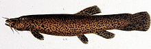
Trichomycterus rivulatus is a species of pencil catfish that is native to high-altitude Andean streams and lakes (including Junin, Poopó and Titicaca) in southern Peru, western Bolivia and northern Chile. It is the largest species in the genus Trichomycterus and grows to a maximum length of 37.4 centimetres (14.7 in) TL. The species is regularly caught as a food fish. However, because of pollution, studies have revealed levels of metals in T. rivulatus of Lake Titicaca that exceed the internationally recommended safety thresholds for human consumption. (Full article...) -
The Pico Pan de Azúcar, at 4680 meters above sea level, is the ninth highest mountain of Venezuela, and the third highest of the Sierra de la Culata range in the Mérida State. Its name, which translates as "Bread of Sugar", is due to the sandy slopes of the mountain, which resembles "Pan dulce", a kind of bread sprinkled with sugar eaten in the country. The summit offers a scenic view, including Lake Maracaibo, Sierra Nevada de Mérida and the surrounding mountains of the Sierra de la Culata. (Full article...)
-
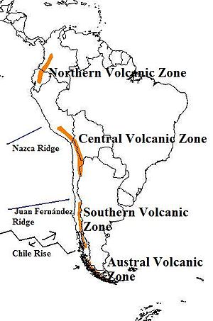
The andes mountains are one of the tallest. Map of the volcanic arcs in the Andes, and subducted structures affecting volcanism
The Andean Volcanic Belt is a major volcanic belt along the Andean cordillera in Argentina, Bolivia, Chile, Colombia, Ecuador, and Peru. It is formed as a result of subduction of the Nazca Plate and Antarctic Plate underneath the South American Plate. The belt is subdivided into four main volcanic zones which are separated by volcanic gaps. The volcanoes of the belt are diverse in terms of activity style, products, and morphology. While some differences can be explained by which volcanic zone a volcano belongs to, there are significant differences within volcanic zones and even between neighboring volcanoes. Despite being a type location for calc-alkalic and subduction volcanism, the Andean Volcanic Belt has a broad range of volcano-tectonic settings, as it has rift systems and extensional zones, transpressional faults, subduction of mid-ocean ridges and seamount chains as well as a large range of crustal thicknesses and magma ascent paths and different amounts of crustal assimilations.
Romeral in Colombia is the northernmost active member of the Andean Volcanic Belt. South of latitude 49° S within the Austral Volcanic Zone volcanic activity decreases with the southernmost volcano Fueguino in Tierra del Fuego archipelago. (Full article...) -
Cerro Bonete is a mountain in the north of the province of La Rioja, Argentina, near the provincial border with Catamarca. Its summit is 6,759 m above mean sea level, making it the fifth-highest separate mountain in the Americas (after Aconcagua, Ojos del Salado, Monte Pissis, and Huascaran). SRTM data disproves the frequently-made claim that its summit is 6,872 m above sea level.
Within the last 3.5 million years, volcanic activity at Cerro Bonete has formed lava domes of dacite and rhyodacite. (Full article...) -
Patilla Pata is a stratovolcano in the Oruro Department in Bolivia. It is situated in the Sajama Province, in the west of the Curahuara de Carangas Municipality, at the border with Chile. Patilla Pata lies south-west of the mountain Jisk'a Kunturiri, north-east of the lake Q'asiri Quta (Khasiri Kkota) and the mountain Qullqi Warani, west of the little lake Sura Pata, south-east of the mountains Laram Q'awa, Kunturiri and Milluni and south of the little lake named Ch'iyar Quta.
The river Junt'uma K'uchu (Aymara junt'u warm, hot, uma water, k'uchu corner, "warm water corner", Junthuma Khuchu) originates south of Patilla Pata. It flows to the south-east as a right affluent of the Sajama River. (Full article...) -

Map showing Iru Phutunqu on the border of Bolivia and Chile, south of the Umani
Iruputuncu (possibly from Aymara iru spiny Peruvian feather grass, phutunqu a small vessel or a hole, pit, crater) is a mountain in the Andes in the Cordillera Occidental on the border of Bolivia and Chile. The Chilean side is in the Tarapacá Region, and the Bolivian side is in the Potosí Department, Daniel Campos Province, Llica Municipality. Iruputuncu is southeast of Mount Candelaria, west of the Salar de Uyuni salt flat and south of the Umani. It is about 4,200 m (13,780 ft) high. (Full article...) -
Tungurahua (/tʊŋɡʊˈrɑːwə/; from Quichua tunguri (throat) and rahua (fire), "Throat of Fire") is an active stratovolcano located in the Cordillera Oriental of Ecuador. The volcano gives its name to the province of Tungurahua. Volcanic activity restarted on August 19, 1999, and is ongoing , with several eruptive episodes since then, the most recent lasting from February 26 to March 16, 2016. (Full article...) -
Santa Isabel (Spanish: Nevado de Santa Isabel) is a shield volcano located in Tolima, Colombia, southwest of Nevado del Ruiz volcano. The volcano is located over the Palestina Fault, that crosscuts the underlying El Bosque Batholith of Eocene age, dated at 49.1 ± 1.7 Ma. (Full article...) -
Orestias is a genus of pupfish. Older systematics classified them into the own family Orestiidae. They are found in lakes, rivers and springs in the Andean highlands of South America, and several species are considered threatened. They are egg-laying fish that feed on small animals and plant matter. The largest species can reach a total length of 27 cm (10.6 in), but most remain far smaller. Their most characteristic feature is the absence of the ventral fin, although this is shared by a few other pupfish. Despite their moderate to small size, they are important to local fisheries and a few species are farmed.
Several species are locally and colloquially known as carache. The name of the genus is a reference to Orestes, a Greek mythological character who Valenciennes described as the "nymph of the mountains". (Full article...) -
Nevado Ojos del Salado is a dormant complex volcano in the Andes on the Argentina–Chile border. It is the highest volcano on Earth and the highest peak in Chile. The upper reaches of Ojos del Salado consist of several overlapping lava domes, lava flows and volcanic craters, with sparse ice cover. The complex extends over an area of 70–160 square kilometres (27–62 sq mi) and its highest summit reaches an altitude of 6,893 metres (22,615 ft) above sea level. Numerous other volcanoes rise around Ojos del Salado.
Being close to the Arid Diagonal of South America, the mountain has extremely dry conditions, which prevent the formation of substantial glaciers and a permanent snow cover. Despite the arid climate, there is a permanent crater lake about 100 m (330 ft) in diameter at an elevation of 6,480 metres (21,260 ft)-6,500 metres (21,300 ft) within the summit crater and east of the main summit. This is the highest lake of any kind in the world. Owing to its altitude and the desiccated climate, the mountain lacks vegetation. (Full article...) -
Antisana is a stratovolcano of the northern Andes, in Ecuador. It is the fourth highest volcano in Ecuador, at 5,753 metres (18,875 ft), and is located 50 kilometres (31 mi) SE of the capital city of Quito.
Antisana presents one of the most challenging technical climbs in the Ecuadorian Andes. Next to the Pichincha, Cotopaxi, Tungurahua and Chimborazo, the Antisana belongs to the five volcanic mountains that the Prussian-born explorer Alexander von Humboldt tried to climb in 1802 during his American journey. (Full article...) -
The Laguna de Sonso Nature Reserve is located in the Valle del Cauca Department of Colombia. It contains the last extensive remnant of original natural wetland remaining in the Cauca River Valley in western Colombia, and was declared a nature reserve in October 1978. It comprises a series of marshes and lagoons on the east bank of the Cauca River, between the municipalities of Buga, Yotoco and Guacari. It has an area of 2,045 ha (7.90 sq mi), lying at an altitude of 935 m (3,068 ft). The wetlands are affected by the introduced water hyacinth. The reserve has been designated as a protected Ramsar site since 2017. (Full article...) -
Monte San Valentin, also known as Monte San Clemente, is the highest mountain in Chilean Patagonia and the highest mountain south of 37°S outside Antarctica. It stands at the north end of the North Patagonian Icefield.
Monte San Valentin can be climbed from Lago Leones, to the south east, or from Laguna San Rafael, to the west. The ascent is long and is particularly subject to bad weather. (Full article...) -
Reventador is an active stratovolcano which lies in the eastern Andes of Ecuador. It lies in a remote area of the national park of the same name, which is Spanish for "exploder". Since 1541, it has erupted over 25 times, although its isolated location means that many of its eruptions have gone unreported.
The largest historical eruption occurred in 2002. During that eruption, the plume from the volcano reached a height of 17 kilometres (11 mi) and pyroclastic flows proceeded to 7 kilometres (4.3 mi) from the cone. On March 30, 2007, the mountain ejected ash to a height of about 3.2 kilometres (2.0 mi). No injuries or damage were reported. Its most recent eruption began on 27 July 2008, and it has remained in continuing eruption status (intermittent eruptive events without a break of 3 months or more) as of 15 October 2021. (Full article...) -
Cotopaxi (Spanish pronunciation: [kotoˈpaksi]) is an active stratovolcano in the Andes Mountains, located near Latacunga city of Cotopaxi Province, about 50 km (31 mi) south of Quito, and 31 km (19 mi) northeast of the city of Latacunga, Ecuador. It is the second highest summit in Ecuador, reaching a height of 5,897 m (19,347 ft). Cotopaxi is among the highest active volcanoes in the world.
Cotopaxi is known to have erupted 87 times, resulting in the creation of numerous valleys formed by lahars (mudflows) around the volcano. An ongoing eruption began on 21 October 2022. (Full article...) -
Huayna Potosí is a mountain in Bolivia, located near El Alto and about 25 km north of La Paz in the Cordillera Real.
Huayna Potosí is the closest high mountain to La Paz. Surrounded by high mountains, it is roughly 15 miles due north of the city, which makes this mountain the most popular climb in Bolivia. The normal ascent route is a fairly straightforward glacier climb, with some crevasses and a steep climb to the summit. However, the other side of the mountain—Huayna Potosí West Face—is the biggest face in Bolivia. Several difficult snow and ice routes ascend this 1,000-meter-high face. (Full article...) -
Cerro del Nacimiento is an Andean volcano of the Cordillera de la Ramada range, in the Catamarca Province of Argentina. Its summit is 6,436 metres (21,115 ft) above sea level. (Full article...) -
Rondoy (possibly from Quechua runtuy: "to hail" or "to lay an egg") is a 5,870-metre-high (19,259 ft) mountain in the north of the Huayhuash mountain range in the Andes of Peru. It is located in the Ancash Region, Bolognesi Province, Pacllón District, and in the Huánuco Region, Lauricocha Province, Queropalca District. Rondoy lies north of Yerupajá and Jirishanca and southwest of Lake Mitococha. (Full article...) -
The Sierra de La Culata is a mountain range in the largest massif in Venezuela, the Cordillera de Mérida, which in turn is part of the northern extent of the Cordillera de los Andes (Andes Mountains). The Sierra la Culata includes some of the highest peaks in Venezuela, such as Pico Piedras Blancas, Pico Pan de Azúcar, and Collado del Cóndor.
It is located between the states of Mérida and Trujillo. Most of the lagoons are a result of the Mérida glaciation. (Full article...)


.jpg)


Did you know...
- ... that the 1930s Polish Andean expeditions have been credited with several first ascents and the tracing of a new route to the summit of Aconcagua, the Andes' highest peak?
Need help?
Do you have a question about Andes that you can't find the answer to?
Consider asking it at the Wikipedia reference desk.
Selected images
-
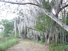
 Laguna de Sonso tropical dry forest in Northern Andes (from Andes)
 -
 Bolivian Andes (from Andes)
 -

-
 Frederic Edwin Church, Heart of the Andes, 1859. (from Andes)
 -

-

-
 A male Andean cock-of-the-rock, a species found in humid Andean forests and the national bird of Peru (from Andes)
 -
 View of Cuernos del Paine in Torres del Paine National Park, Chile (from Andes)
 -

-

-

-

-

-
 Peruvian farmers sowing maize and beans (from Andes)
 -

-

-
 Aerial view of Valle Carbajal in the Tierra del Fuego. The Andes range is about 200 km (124 mi) wide throughout its length, except in the Bolivian flexure where it is about 640 kilometres (398 mi) wide. (from Andes)
 -

-
 Nevado del Huila, Colombia (from Andes)
 -
 Central Andes (from Andes)
 -
 Pico Humboldt at sunset (from Andes)
 -
 Irrigating land in the Peruvian Andes (from Andes)
 -
 Parinacota, Bolivia/Chile (from Andes)


.jpg)


.jpg)


%E2%80%93Valle_Carbajal_01.jpg)

.jpg)


Subcategories

- Select [►] to view subcategories
Subtopics
Associated Wikimedia
The following Wikimedia Foundation sister projects provide more on this subject:
-
 Commons
Free media repository -
 Wikibooks
Free textbooks and manuals -
 Wikidata
Free knowledge base -
 Wikinews
Free-content news -
 Wikiquote
Collection of quotations -
 Wikisource
Free-content library -
 Wikiversity
Free learning tools -
 Wiktionary
Dictionary and thesaurus
-->