
User:Ɱ/Portal:Columbus, Ohio
Portal maintenance status: (October 2021)
|
Introduction

Columbus (/kəˈlʌmbəs/, kə-LUM-bəs) is the capital and most populous city of the U.S. state of Ohio. With a 2020 census population of 905,748, it is the 14th-most populous city in the U.S., the second-most populous city in the Midwest after Chicago, and the third-most populous U.S. state capital after Phoenix, Arizona and Austin, Texas. Columbus is the seat of government of Franklin County; it also extends into Delaware and Fairfield counties. It is the core city of the Columbus metropolitan area, which encompasses ten counties in central Ohio. It had a population of 2,138,926 in 2020, making it the largest metropolitan area entirely in Ohio and 32nd-largest metro area in the U.S.
Columbus originated as numerous Native American settlements on the banks of the Scioto River. Franklinton, now a city neighborhood, was the first European settlement, laid out in 1797. The city was founded in 1812 at the confluence of the Scioto and Olentangy rivers, and laid out to become the state capital. The city was named for Italian explorer Christopher Columbus. The city assumed the function of state capital in 1816 and county seat in 1824. Amid steady years of growth and industrialization, the city has experienced numerous floods and recessions. Beginning in the 1950s, Columbus began to experience significant growth; it became the largest city in Ohio in land and population by the early 1990s. Growth has continued in the 21st century, with redevelopment occurring in numerous city neighborhoods, including Downtown. (Full article...)
Selected general articles
-

-
Columbus, Ohio has a humid continental (Köppen climate classification Dfa) climate, characterized by humid, hot summers and cold winters, with no dry season. The Dfa climate has average temperatures above 22 °C (72 °F) during the warmest months, with at least four months averaging above 10 °C (50 °F), and below 0 °C (32 °F) during the coldest. The climate is transitional with the Cfa humid subtropical climate to the south, characterized by humid, hot summers and cool winters (an average temperature above 0 °C (32 °F) but below 18 °C (64.4 °F) during the coldest months).
Columbus is within USDA hardiness zone 6a. Winter snowfall is relatively light, since the city is not in the typical path of strong winter lows, such as the Nor'easters that strike cities farther east. It is also too far south and west for lake-effect snow from Lake Erie to have much effect, although the lakes to the North contribute to long stretches of cloudy spells in winter.
Columbus is subject to severe weather typical to the Midwestern United States. Severe thunderstorms can bring lightning, large hail and on rare occasion tornadoes, especially during the spring and sometimes through fall. (Full article...) -
Miami-Jacobs Career College is a private for-profit career college with locations throughout Ohio. Miami-Jacobs Career College has locations in several Ohio cities: Columbus, Dayton, Sharonville, Springboro, and Troy. (Full article...)
-

Columbus State Community College (CSCC) is a public community college in Columbus, Ohio. Founded as Columbus Area Technician's School in 1963, it was renamed Columbus Technical Institute in 1965 and was renamed again to its current name in 1987. The college has grown from an initial enrollment of 67 students in 1963, to its current enrollment of over 27,000 students over two campuses, nine regional learning centers, and online courses. (Full article...) -
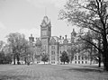
The Ohio Statehouse is the state capitol building and seat of government for the U.S. state of Ohio. The Greek Revival building is located on Capitol Square in Downtown Columbus. The capitol houses the Ohio General Assembly, consisting of the House of Representatives and the Senate. It also contains the ceremonial offices of the governor, lieutenant governor, state treasurer, and state auditor. Built between 1839 and 1861, it is one of the oldest working statehouses in the United States. The statehouse grounds include two other buildings, the Judiciary Annex or Senate Building, and the Atrium; the three are collectively referred to as the Ohio Statehouse into the present day.
The statehouse's prominent architecture has earned it several landmark designations, including as a National Historic Landmark. The building sees about 500,000 visitors per year. (Full article...) -

The Columbus City Council is the lawmaking body of Columbus, Ohio. It has 7 members who are elected at-large. It meets in the City Council Chambers located on the second floor of Columbus City Hall. Starting in the 2023 election, City Council will expand to 9 members and be elected by district in a primary election and then at large in the November general election. In the 2023 election, all members will run for another term. Four members will only serve a two-year term while the other five will serve a four-year term. Although the city is divided into nine districts, voters within Columbus vote for all nine council members. (Full article...) -
Ohio Dominican University is a private Dominican liberal arts university in Columbus, Ohio. In 2024, the university had 1,252 students and offered undergraduate degrees in 42 majors as well as 9 graduate degree programs. (Full article...)
-

The Ohio State Buckeyes are the intercollegiate athletic teams that represent Ohio State University, located in Columbus, Ohio. The athletic programs are named after the colloquial term for people from the state of Ohio and after the state tree, the Ohio buckeye. The Buckeyes participate in the National Collegiate Athletic Association's (NCAA) Division I in all sports and the Big Ten Conference in most sports. The Ohio State women's ice hockey team competes in the Western Collegiate Hockey Association (WCHA). The school colors are scarlet and gray. The university's mascot is Brutus Buckeye. "THE" is the official trademark of the Ohio State University merchandise. Led by its gridiron program, the Buckeyes have the largest overall sports endowment of any campus in North America.
Ohio State is one of only seven universities to have won an NCAA national championship in baseball and men's basketball, and be recognized as a national champion in football. Ohio State has also won national championships in women's ice hockey, men's swimming & diving, men's outdoor track & field, men's volleyball, men's golf, men's gymnastics, men's fencing, women's rowing, co-ed fencing, co-ed and women's pistol, synchronized swimming, and wrestling. Since the inception of the Athletic Director's Cup, Ohio State has finished in the top 25 each year, including top 6 finishes in three of the last five years. During the 2005–06 school year Ohio State became the first Big Ten team to win conference championships in football, men's basketball and women's basketball in the same season. This feat repeated in the 2006–07 season, which also included a February 25, 2007 men's basketball game which saw the Buckeyes defeat the Wisconsin Badgers in the Big Ten's first basketball game between the number one and number two ranked squads in the nation.
A few of the many outstanding sports figures who were student athletes at Ohio State include Jesse Owens, "The Buckeye Bullet" (track and field), John Havlicek, Jerry Lucas, and Katie Smith (basketball), Frank Howard (baseball), Jack Nicklaus (golf), Archie Griffin (football running back, the only two-time Heisman Trophy winner), and Chic Harley (three-time All-American football running back). Hall of Fame coaches at Ohio State have included Paul Brown and Woody Hayes (football), Fred Taylor (men's basketball). Notable sports figures in Ohio State history may be inducted into the Ohio State Varsity O Hall of Fame. (Full article...) -
The Ohio Aviators are an American rugby union team that played professionally in the short lived PRO Rugby competition. They are based in the Columbus, Ohio metropolitan area, and played their home games at Memorial Park in Obetz, Ohio. They are now playing in the newly formed World Tens Series. (Full article...)
-

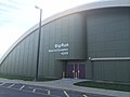
The Greater Columbus Convention Center (GCCC) is a convention center located in Downtown Columbus, Ohio, United States, along the east side of North High Street.
The convention center was predominantly designed by Peter Eisenman, constructed in 1993, and expanded in 1999 and again in 2016. Venue management company ASM Global oversees day-to-day operations of the 1.8-million-square-foot (170,000 m2) facility, including 447,000 square feet (41,500 m2) of exhibit space, three ballrooms, and 75 meeting rooms. (Full article...) -
Whitehall is a city in the U.S state of Ohio, located 6.6 miles (10.6 km) east of the state capital of Columbus in Franklin County. Whitehall had a population of 20,127 in the 2020 census. Founded in 1947, Whitehall is a growing suburb of Columbus. Per the U.S. Census Bureau, Whitehall's population is culturally and racially diverse, with over 50% of the population identifying as black, African American, Hispanic or Latino, with over 20% speaking a language other than English at home. (Full article...) -
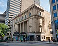
The Ohio Theatre is a performing arts center and former movie palace on Capitol Square in Downtown Columbus, Ohio. Known as the "Official Theatre of the State of Ohio", the 1928 building was saved from demolition in 1969 and was later completely restored. The theater was declared a National Historic Landmark in 1977.
The Ohio Theatre is owned and operated by the non-profit arts management organization CAPA (The Columbus Association for the Performing Arts), which was originally formed to save the theater in 1969. (Full article...) -
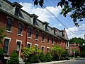
The Old Beechwold Historic District is a neighborhood and historic district in Clintonville, Columbus, Ohio. The site was listed on the Columbus Register of Historic Properties in 1985 and the National Register of Historic Places in 1987. The district is significant for its architecture, landscape architecture, and community planning. The houses are of the early 20th century, using stone, brick, and stucco.
The land was originally part of a large tract owned by a single family, but in 1902, 75 of those acres were sold to the Columbus Zoological Company. The company established one of the first zoos in Columbus, known as "The Zoo", that failed after only five months, opening in May and closing in November of 1905. In 1906, Joseph A. Jeffrey acquired the land, and created a suburban estate named "Beechwalde". He built the two oldest houses in the district. The former monkey house can still be seen on the property of 150 West Beechwold Boulevard where it is used as a barn. The zoo's original brick entrance can also be seen on North High Street at Beechwold Road. (Full article...) -

Bolton Field (ICAO: KTZR, FAA LID: TZR) is a public airport in Columbus, Franklin County, Ohio, United States. It is a towered airport operated under the Columbus Regional Airport Authority. It is one of 12 general aviation reliever airports in Ohio recognized in the National Plan of Integrated Airport Systems (NPIAS) and is a reliever airport for John Glenn Columbus International Airport.
Most U.S. airports use the same three-letter location identifier for the FAA and IATA, but Bolton Field is TZR to the FAA and has no IATA code. (Full article...) -
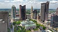
Downtown Columbus is the central business district of Columbus, Ohio. Downtown is centered on the intersection of Broad and High Streets, and encompasses all of the area inside the Inner Belt. Downtown is home to most of the tallest buildings in Columbus.
The state capitol, the Ohio Statehouse, is located in the center of downtown on Capitol Square. Downtown is also home to Columbus State Community College, Franklin University, Columbus College of Art and Design, Grant Medical Center, Capital University Law School, as well as the Main Library of the Columbus Metropolitan Library, the pioneering Main Street Bridge, and many parks.
Downtown has many neighborhoods or districts, but it can be separated into three main areas: the Discovery District, the High Street Corridor, and the Riverfront. Downtown also includes the Arena District, Capitol Square, and the Columbus Civic Center. The Short North, Italian Village, and Victorian Village are directly north of downtown. The Warehouse District,Olde Towne East and King-Lincoln Bronzeville are directly east, while the Brewery District and German Village are directly south of Downtown. Franklinton is to the west of downtown. (Full article...) -

Huntington Center in downtown Columbus
Columbus, Ohio has a generally strong and diverse economy based on education, insurance, banking, fashion, defense, aviation, food, logistics, steel, energy, medical research, health care, hospitality, retail, and technology.
Prominent employers in the Columbus area include numerous schools (e.g., The Ohio State University) and hospitals, hi-tech research and development and information/library companies such as Battelle Memorial Institute, OCLC, and Chemical Abstracts, and retail clothing and restaurant companies (such as Limited Brands and Wendy`s). Other large employers include Alliance Data, Nationwide Insurance, JP Morgan Chase, American Electric Power, Huntington Bancshares, Worthington Industries and Cardinal Health, not to mention both state and local government. (Full article...) -
University, Hayes and Orton Halls are three historic buildings on the Oval at the Ohio State University in Columbus, Ohio. On July 16, 1970, they were added to the National Register of Historic Places. The original University Hall was demolished in 1971, and removed from the National Register that year. (Full article...) -
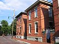
The Brewery District, traditionally known as the Old German Brewing District, is a neighborhood located in Columbus, Ohio. Located just south of the central business district and west of German Village, it is bounded by Interstate 70 on the north, South Pearl Street on the east, Greenlawn Avenue on the south, and the Scioto River on the west. (Full article...) -
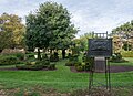
Topiary Park is a 9.2-acre (3.7 ha) public park and garden in Columbus, Ohio's Discovery District. The park's topiary garden, officially the Topiary Garden at Old Deaf School Park, is designed to depict figures from Georges Seurat's 1884 painting, A Sunday Afternoon on the Island of La Grande Jatte. It is the only park based entirely on a painting.
The park is officially named Old Deaf School Park, as it was part of the campus of the Ohio Institution for the Deaf and Dumb, known today as the Ohio School for the Deaf. It is owned by the city of Columbus and maintained by the Columbus Recreation and Parks Department. (Full article...) -
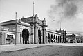
Columbus Union Station was an intercity train station in Downtown Columbus, Ohio, near The Short North neighborhood. The station and its predecessors served railroad passengers in Columbus from 1851 until April 28, 1977.
The first station building was the first union station in the world, built in 1851. Its replacement was built from 1873 to 1875, just before demolition of the first station building. After traffic problems on High Street, as well as increased rail traffic became problematic, a new station was planned by Daniel Burnham beginning in 1893. The new station opened in 1897, and its arcade along High Street was finished in 1899. By 1928, part of the arcade was demolished. Passenger service significantly declined from the 1950s to the 1970s. The arcade was demolished in 1976 to make way for a new convention center, although it had been placed on the National Register of Historic Places two years prior. Train service stopped at Union Station in 1977, and the remaining portions of the station were demolished in 1979. The demolished arcade was delisted in 1999. A portion of the arcade was saved, the Union Station arch, which is the focal point of the McFerson Commons park in the nearby Arena District. (Full article...) -
Value City Arena is a multi-purpose arena, located on the campus of Ohio State University, in Columbus, Ohio, United States. The arena opened in 1998 and is currently the largest by seating capacity in the Big Ten Conference, with 19,049 seats, which is reduced to 18,809 for Ohio State men's and women’s basketball games.
It is home to Ohio State Buckeyes men's basketball, women's basketball and men's ice hockey teams. Previously, the basketball teams played at St. John Arena, while the ice hockey team played at the OSU Ice Arena. The facility is named the Jerome Schottenstein Center in honor of Jerome Schottenstein, of Columbus, late founder of Schottenstein Stores Corp. and lead benefactor of the project, while the seating bowl is named for Schottenstein's store Value City Furniture. (Full article...) -

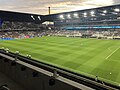
Lower.com Field is a soccer-specific stadium in Columbus, Ohio, United States. It serves primarily as the home stadium of the Columbus Crew of Major League Soccer, replacing the club's previous home, Historic Crew Stadium. The new stadium cost $314 million and is located at the center of the mixed-use Astor Park development adjacent to the Arena District and downtown. It seats 20,371 spectators and includes 30 suites and 1,900 club seats. (Full article...) -
Columbus Japanese Language School (コロンバス日本語補習校, Koronbasu Nihongo Hoshūkō, CJLS) is a weekend supplementary Japanese school, based in the Columbus, Ohio metropolitan area.
The classes are held in Creekview Intermediate School, of the Marysville Exempted Village Schools District (MEVSD) in Marysville. The school office is located in Worthington. (Full article...) -
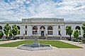
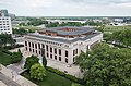
The Main Library of the Columbus Metropolitan Library (CML) system is located in Downtown Columbus, Ohio, United States. The public library is the largest in the library system and holds approximately 300,000 volumes. It includes numerous rooms, including separate spaces for children, teens, an adult reading room, newspaper room, auditorium, gallery, gift shop, and a cafe. The third floor includes a computer lab and houses the Franklin County Genealogical & Historical Society.
The library building was proposed as early as 1901 when the public used a reading room in Columbus's city hall. In 1903, Andrew Carnegie largely funded its construction, making it a Carnegie library. The library was designed by Albert Randolph Ross in the Beaux-Arts style, using white Vermont marble. The building opened in 1907. It was first expanded in 1953 and 1961, followed by a 1991 addition and the demolition of the two prior structures; the process tripled the building's size. In 2015 and 2016, another renovation took place to increase reader space, add to its west lawn, join the building to Topiary Park at its east, and clad most of the 1991 building in glass. (Full article...) -
Northland is a residential and commercial area in northeast Columbus, Ohio. The area is served by the Northland Community Council, which oversees land east of Worthington, roughly north of Morse Road, south of I-270, and west of New Albany, including the neighborhood Forest Park and the independent village of Minerva Park.
The area has one of the largest populations of new American citizens in Columbus, including thousands of refugees from Nepal, Somalia, and Bhutan. (Full article...)


.jpg)


Need help?
Do you have a question about Columbus, Ohio that you can't find the answer to?
Consider asking it at the Wikipedia reference desk.
Selected images
-
-
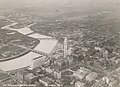
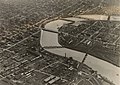 Downtown Columbus and the Scioto River c. 1924 (from Columbus, Ohio)
 -
 Central Market stood on Fourth Street from 1850 to 1966 (from History of Columbus, Ohio)
 -

-
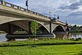
 Panorama of downtown Columbus from the Main Street Bridge (from Columbus, Ohio)
 -
 The Discovery Bridge (from Columbus, Ohio)
 -
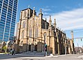
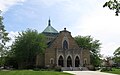 St. Mary Magdalene Church in Westgate (from Neighborhoods in Columbus, Ohio)
 -
 Shrum Mound, the feature of Campbell Memorial Park (from History of Columbus, Ohio)
 -
 Locations of numbered streets and avenues (from Columbus, Ohio)
 -
-
 Old North Columbus Arch (from Neighborhoods in Columbus, Ohio)
 -
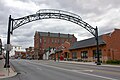
 The iconic arches of the Short North (from Neighborhoods in Columbus, Ohio)
 -
 Victorian houses facing Goodale Park in Victorian Village (from Columbus, Ohio)
 -
 Map of land surveys and city boundary growth, 1812–1920 (from History of Columbus, Ohio)
 -
 Bird's eye view map of Columbus in 1872 (from History of Columbus, Ohio)
 -
 Lou Berliner Sports Park (from List of parks in Columbus, Ohio)
 -
 Ohio Stadium, on the campus of Ohio State University, is the 5th-largest non-racing stadium in the world. (from Columbus, Ohio)
 -

-
 North Market (from Columbus, Ohio)
 -
-
 Skyline of Columbus (Use cursor to identify buildings) (from List of tallest buildings in Columbus, Ohio)
 -

-
Shrum Mound in Campbell Memorial Park (from Columbus, Ohio)
-
 Map of the Ohio Country between 1775 and 1794, depicting locations of battles and massacres surrounding the area that would eventually become the U.S. state of Ohio (from Columbus, Ohio)
 -
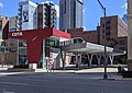 COTA's Spring Street Terminal, one of its five transit centers (from Columbus, Ohio)
 -
 Racial distribution in Columbus in 2010: ⬤ White ⬤ Black ⬤ Asian ⬤ Hispanic ⬤ Other (from Columbus, Ohio)
 -
Bird's eye view map of Columbus in 1872 (from Columbus, Ohio)
-
 The city in 1936 (from Columbus, Ohio)
 -
Map of the Ohio Country between 1775 and 1794, depicting locations of battles and massacres surrounding the area that would eventually become Ohio (from History of Columbus, Ohio)
-
-
-
-
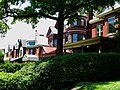
 Homes in German Village (from Neighborhoods in Columbus, Ohio)
 -

-
Central Market, pictured here in 1898, operated from 1814 to 1966. (from Columbus, Ohio)
-
 The Art Deco LeVeque Tower is the city's second-tallest skyscraper. (from Columbus, Ohio)
 -
-
-

-
 Barlouie (from Neighborhoods in Columbus, Ohio)
 -
 The Merion Village arch (from Neighborhoods in Columbus, Ohio)
 -
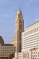 The LeVeque Tower was the tallest building in Columbus from 1927 to 1973. (from List of tallest buildings in Columbus, Ohio)
 -
The city c. 1924 (from History of Columbus, Ohio)
-
 West Broad Street in Franklinton (from Neighborhoods in Columbus, Ohio)
 -

-
 Eastern side of Olentangy Commons (from Neighborhoods in Columbus, Ohio)
 -

-
 Big Run Sports Complex, in Big Run Park (from Neighborhoods in Columbus, Ohio)
 -
 Brewery District Scene (from Neighborhoods in Columbus, Ohio)
 -

-
 Aerial satellite image of Columbus (from Columbus, Ohio)
 -
 Port Columbus Airport tower and terminal from 1929 to 1958 (from Columbus, Ohio)
 -

-
2010 Census-based map: red dots indicate white Americans, blue dots for African Americans, green for Asian Americans, orange for Hispanic Americans, yellow for other races. Each dot represents 25 residents. (from Neighborhoods in Columbus, Ohio)
-
 Municipal offices, including the Columbus Division of Police Headquarters, in the city's Civic Center (from Columbus, Ohio)
 -
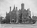
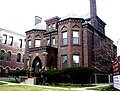
 The Pontifical College Josephinum (1888-1931) (from List of demolished buildings and structures in Columbus, Ohio)
 -
 View of the city from Capital University in 1854 (from Columbus, Ohio)
 -
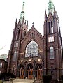
 Hungarian Reform Church, in Hungarian Village (from Neighborhoods in Columbus, Ohio)
 -
 Indianola Junior High School was the first middle school in the U.S. (from Columbus, Ohio)
 -
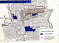 1954 urban renewal map of Columbus (from List of demolished buildings and structures in Columbus, Ohio)
 -
 The Santa Maria Ship & Museum, a Santa María replica, was docked downtown from 1991 to 2014. (from Columbus, Ohio)
 -
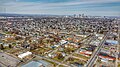 Aerial view of Reeb-Hosack (from Neighborhoods in Columbus, Ohio)
 -
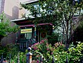
 Home in Old Oaks (from Neighborhoods in Columbus, Ohio)
 -
 Historic Home in Harrison West (from Neighborhoods in Columbus, Ohio)
 -
 Dutch Colonial Style residences in Hungarian Village (from Neighborhoods in Columbus, Ohio)
 -
 The Columbus Museum of Art collects and exhibits American and European modern and contemporary art, folk art, glass art, and photography. (from Columbus, Ohio)
 -
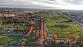
 The Ohio State Fair is held in late July to early August. (from Columbus, Ohio)
 -
 Hilltop signage (from Neighborhoods in Columbus, Ohio)
 -
 Columbus City Hall (from Columbus, Ohio)
 -
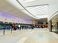 John Glenn Columbus International Airport departure level (from Columbus, Ohio)
 -
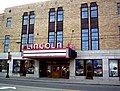 The historic Lincoln Theatre (from Neighborhoods in Columbus, Ohio)
 -

-
 COSI (east entrance pictured) features themed, interactive science exhibits. (from Columbus, Ohio)
 -
 Camp Chase as it stands today, a memorial to fallen soldiers from the American Civil War. (from Neighborhoods in Columbus, Ohio)
 -

-
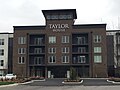 Taylor House on Bethel Rd. (from Neighborhoods in Columbus, Ohio)
 -
 Victorian-style homes located along Goodale Park (from Neighborhoods in Columbus, Ohio)
 -
-
Columbus in 1936 (from History of Columbus, Ohio)
-
-
 Italian Village rowhouse (from Neighborhoods in Columbus, Ohio)
 -
View of the city from Capital University in 1854 (from History of Columbus, Ohio)
-
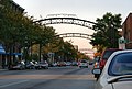
 Street arches returned to the Short North in late 2002. (from History of Columbus, Ohio)
 -
 Four of the city's five tallest buildings are around Capitol Square (from List of tallest buildings in Columbus, Ohio)
 -
-
-
 Holy Rosary and Saint John Church (from Neighborhoods in Columbus, Ohio)
 -
 Arcade of the third Union Station, the city's rail station from 1897 to 1977 (from Columbus, Ohio)
 -
 Audubon nature center at Scioto Audubon Metro Park, the first built close to a major city's downtown (from Columbus, Ohio)
.jpg)


_-_exterior_2.jpg)


.png)
.jpg)
.jpg)


_crop.jpg)


.jpg)


Subcategories

- Select [►] to view subcategories
Subtopics
| Topics |  | ||||||
|---|---|---|---|---|---|---|---|
| Neighborhoods | |||||||
| Enclaves | |||||||
| History |
| ||||||
| Attractions | |||||||
| Government |
| ||||||
| Education |
| ||||||
| Transportation |
| ||||||
| Sports |
| ||||||
| Museums |
| ||||||
| |||||||
Associated Wikimedia
The following Wikimedia Foundation sister projects provide more on this subject:
-
 Commons
Free media repository -
 Wikibooks
Free textbooks and manuals -
 Wikidata
Free knowledge base -
 Wikinews
Free-content news -
 Wikiquote
Collection of quotations -
 Wikisource
Free-content library -
 Wikiversity
Free learning tools -
 Wiktionary
Dictionary and thesaurus
Category:United States portals by city Category:Portals needing placement of incoming links