
Dashalty
Dashalty / Karin Tak
Daşaltı / Քարին Տակ | |
|---|---|
 Village in June 2015 | |
 Dashalty / Karin Tak | |
| Coordinates: 39°44′30″N 46°44′57″E / 39.74167°N 46.74917°E | |
| Country | |
| District | Shusha |
| Population (2015)[1] | |
| • Total | 660 |
| Time zone | UTC+4 (AZT) |
Dashalty (Azerbaijani: Daşaltı) or Karin Tak (Armenian: Քարին Տակ) is a village in the Shusha District of Azerbaijan,[2][3] in the region of Nagorno-Karabakh. Until 2020, the village was controlled by the unrecognised Republic of Artsakh. The village had an ethnic Armenian-majority population prior to the 2020 Nagorno-Karabakh war, and also had an Armenian majority in 1989.[4]
About 3 km downriver there is a mossy waterfall named "Zontik" (Russian: Зонтик, literally, "Umbrella"), because of its resemblance to an umbrella in the rain. The village is an overnight stopping point along the Janapar hiking trail.
On November 7, 2021, President of the Republic of Azerbaijan Ilham Aliyev and First Lady Mehriban Aliyeva laid the foundation of the Dashalti village Mosque[5]. It is planned to create a network of reservoirs to supply drinking water to Dashalti and the city of Shusha[6]. On July 21, 2023, President of Azerbaijan Ilham Aliyev, during his visit to the village of Dashalty, got acquainted with the work ahead for the reconstruction of the village, and also laid the foundation for a new residential complex and tourist facilities that will be built there through private investment[7]. The upcoming work covers an area of about 65 hectares, where 220 families are planned to be resettled[8]. It is planned that a total population of 1,100 people will be accommodated here. In total, it is planned to build 228 houses for residents: 9 of them will be two-storey multi-apartment buildings, there will also be 66 two-storey townhouses, and 153 two-storey private houses will also be built[7].
Etymology[edit]
Both the Azerbaijani and Armenian names of the village mean "below the rock", referring to the sheer vertical cliffs towering above the village, on top of which Shusha is built.
History[edit]
During the Soviet period, the village was part of the Shusha District of the Nagorno-Karabakh Autonomous Oblast. After the First Nagorno-Karabakh War, the village was administrated as part of the Shushi Province of the breakaway Republic of Artsakh. Shusha, located just above the village, was the last Azerbaijani stronghold in Nagorno-Karabakh to be captured by Armenian forces in the First Nagorno-Karabakh War.[9] On January 26, 1992 Azerbaijani Defense Minister Mehdiyev "led a disastrous sortie out of Shusha to capture the Armenian village of Karintak",[10] in which dozens of Azerbaijani soldiers died.[11]
On 9 November 2020, the last day of the 2020 Nagorno-Karabakh war, Azerbaijani troops regained control over the village[12], and one day before that, over the city of Shusha itself[13].
Historical heritage sites[edit]
Historical heritage sites in and around the village include a 13th-century khachkar, an 18th/19th-century cemetery, an 18th/19th-century bridge, a 19th-century watermill, and the church of Surb Astvatsatsin (Armenian: Սուրբ Աստվածածին, lit. 'Holy Mother of God') built in 1862.[1]
The old town square is relatively well preserved, showing some traditional pre-Soviet architecture of the region. There is also a plain village church that was restored by Land and Culture Organization volunteers in 1999–2000. It was originally built in 1816 in the place of a previously existing chapel.[14]
Demographics[edit]
The village had 588 inhabitants in 2005,[15] and 660 inhabitants in 2015.[1]
Gallery[edit]
-
 Village street
 -
 Monument dedicated to the fallen in WWII and the First Nagorno-Karabakh War
 -
 The church of Surb Astvatsatsin, built in 1862
 -
 "Zontik" (Umbrella) waterfall in the Karkar Canyon
 -
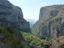 Karkar river canyon
 -
 Section of the Janapar hiking trail passing by the village
 -
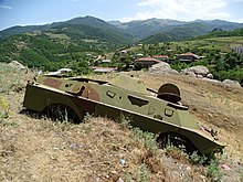 Destroyed military vehicle
 -
 General view


References[edit]
- ^ a b c Hakob Ghahramanyan. "Directory of socio-economic characteristics of NKR administrative-territorial units (2015)".
- ^ "İnzibati ərazi bölgüsü təsnifatı, 2024". www.azstat.org (in Azerbaijani). Archived from the original on 2023-04-07. Retrieved 2024-03-05.
- ^ "İnzıbatı Ərazı Bölgüsü Təsnıfati, 2024" (PDF). Baku: Azərbaycan Respublıkasinin Dövlət Statıstıka Komıtəsı. Təsnifat T.Y.Budaqovun rəhbərliyi ilə Y.X.Yusifov, V.H.Məmmədəlizadə, L.H.Salamzadə və F.E. Qocayev tərəfindən işlənib hazırlanmışdır. 2024. p. 95.
- ^ Андрей Зубов. "Андрей Зубов. Карабах: Мир и Война". drugoivzgliad.com.
- ^ "Ilham Aliyev examined construction progress of Dashalti village mosque » Official web-site of President of Azerbaijan Republic". president.az. Retrieved 2024-05-30.
- ^ "Обсуждены вопросы по созданию водохранилищ в селе Дашалты". azertag.az (in Russian). Archived from the original on 2022-01-17. Retrieved 2022-01-17.
- ^ a b "Ilham Aliyev examined reconstruction works to be carried out in Dashalti village of Shusha district » Official web-site of President of Azerbaijan Republic". president.az. Retrieved 2024-05-30.
- ^ "В селе Дашалты Шушинского построят инфраструктуру для проживания 1,1 тыс. человек". interfax.az. Retrieved 2024-05-08.
- ^ Carey Goldberg (1992-05-10). "Armenians Capture Key Karabakh Town : Republics: Both sides agree the fall of the last Azerbaijani stronghold marks a turning point in the four-year struggle over the disputed enclave". Los Angeles Times. Retrieved 2011-09-27.
- ^ Black Garden, Thomas de Waal, page 176
- ^ Black Garden, Thomas de Waal, page 292
- ^ "President Ilham Aliyev: Victorious Azerbaijani Army liberated 48 more villages, 1 settlement and 8 strategic hills from occupation". Azerbaijan State News Agency. 9 November 2020.
- ^ Kottasová, Aren Melikyan,Arzu Geybulla,Gul Tuysuz,Mary Ilyushina,Tim Lister,Ivana (2020-11-09). "Azerbaijan, Armenia and Russia sign peace deal over Nagorno-Karabakh". CNN. Retrieved 2024-05-30.
{{cite web}}: CS1 maint: multiple names: authors list (link) - ^ Mkrtchyan, Shahen. Historical-Architectural Monuments of Nagorno Karabagh. Yerevan, 1989. (Շահեն Մկրտչյան, «Լեռնային Ղարաբաղի պատմաճարտարապետական հուշարձանները»)
- ^ "The Results of the 2005 Census of the Nagorno-Karabakh Republic" (PDF). National Statistic Service of the Republic of Artsakh.
External links[edit]

| Rural communities |  | |
|---|---|---|
| Not under Artsakh control | ||